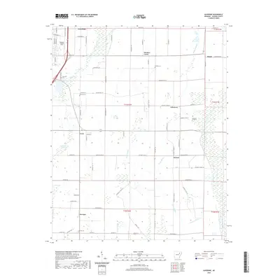
2020 Map of Auvergne
USGS Topo · Published 2020About this map
Auvergne and the southern outskirts of Newport anchor this landscape in Jackson County, where the agricultural flats are defined by an intricate network of drainage ditches and bayous. The eastern edge is shaped by the winding Cache River, while internal drainage is managed by features like the Cypress Cr Ditch and Locust Cr Ditch. This geography reflects a long history of water management to support the local farming economy, punctuated by small crossroads communities such as Remmel, Johnstown, and Erwin. Genealogists will find several burial sites preserved across these sections, including the Johnstown Cemeteries and Sand Hill Cem. Aviation history is represented by the Haigwood Landing Strip situated near the northern boundary, illustrating the integration of air transport into this rural setting. The prevalence of sloughs, such as Turkey Slough and Overcup Slough, reveals the naturally low-lying character of the terrain before the development of the extensive ditch system.
Find a feature on this map
79 named features on this map. Tap any name to fly to it.
Don’t see what you’re looking for? This feature index may not catch every label — zoom into the map to look around manually.
Map Details
Editions of this 2020 Auvergne Map
This is the sole edition of this map. No revisions or reprints were ever made.
Other maps of this area

1935 · Newport
USGS Topo · 1:62,500

1935 · Augusta
USGS Topo · 1:62,500

1935 · Tuckerman
USGS Topo · 1:62,500

1940 · Tilton
USGS Topo · 1:62,500

1953 · Memphis
USGS Topo · 1:250,000

1956 · Memphis
USGS Topo · 1:250,000

1956 · Tilton
USGS Topo · 1:62,500

1957 · Augusta
USGS Topo · 1:62,500

1962 · Jacksonport
USGS Topo · 1:24,000

1962 · Newport
USGS Topo · 1:24,000