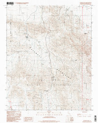
1996 Map of Avawatz Pass
USGS Topo · Published 1998About this map
Fort Irwin Military Reservation encompasses the rugged high-desert landscape of this quadrangle, where the southern boundary of Death Valley meets the Avawatz Mountains. The map serves as a detailed record of remote prospecting and water sources essential for survival in this arid environment. Dozens of sites marked simply as Prospect or Prospects are scattered across the slopes, indicating a long history of mineral exploration that predates the military's current use of the land. Critical water points like Denning Spring, Cave Spring, and Arrastre Spring appear along the mountain flanks, providing the necessary lifeblood for the early mining activities and travel through the Avawatz Pass. The terrain is defined by steep elevation changes and the transitional geology between the desert floor and these isolated peaks.
Find a feature on this map
13 named features on this map. Tap any name to fly to it.
Don’t see what you’re looking for? This feature index may not catch every label — zoom into the map to look around manually.
Map Details
Editions of this 1996 Avawatz Pass Map
This is the sole edition of this map. No revisions or reprints were ever made.
Other maps of this area

1933 · Avawatz Mountains
USGS Topo · 1:250,000

1947 · Trona
USGS Topo · 1:250,000

1948 · Red Pass Lake
USGS Topo · 1:62,500

1948 · Trona
USGS Topo · 1:250,000

1948 · Leach Lake
USGS Topo · 1:62,500

1948 · Avawatz Pass
USGS Topo · 1:62,500

1948 · Tiefort Mountains
USGS Topo · 1:62,500

1951 · Tiefort Mountains
USGS Topo · 1:62,500

1951 · Avawatz Pass
USGS Topo · 1:62,500

1951 · Red Pass Lake
USGS Topo · 1:62,500