
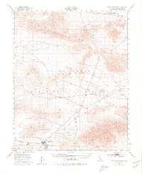
1948 Map of Tiefort Mountains
USGS Topo · Published 1966About this map
The Camp Irwin Military Reservation dominates this High Desert landscape, captured here in a 1948 survey that documents the post-war footprint of this Mojave training ground. Military infrastructure is localized around the Camp Irwin settlement in the southwest, where a Firing Range and Sewage Disposal plant are situated near the desert floor. The vast expanse of the map is defined by the stark topography of the Granite Mountains to the north and the Tiefort Mountains in the south, separated by expansive playas including Bicycle Lake and Drinkwater Lake. This era shows the critical reliance on isolated water sources in a barren environment, marked by Drinkwater Spring and Devouge Spring, alongside a lone Cem (cemetery) located amidst the alluvial fans of the central range.
Find a feature on this map
12 named features on this map. Tap any name to fly to it.
Don’t see what you’re looking for? This feature index may not catch every label — zoom into the map to look around manually.
Map Details
Editions of this 1948 Tiefort Mountains Map
2 editions found
Other maps of this area

1933 · Avawatz Mountains
USGS Topo · 1:250,000

1947 · Trona
USGS Topo · 1:250,000

1948 · Red Pass Lake
USGS Topo · 1:62,500

1948 · Trona
USGS Topo · 1:250,000

1948 · Alvord Mountain
USGS Topo · 1:62,500

1948 · Cave Mountain
USGS Topo · 1:62,500

1948 · Quail Mountains
USGS Topo · 1:62,500

1948 · Lane Mountain
USGS Topo · 1:62,500

1948 · Leach Lake
USGS Topo · 1:62,500

1948 · Avawatz Pass
USGS Topo · 1:62,500