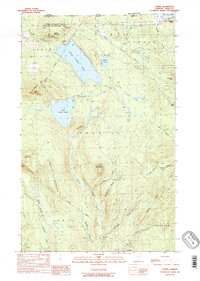
1989 Map of Averill
USGS Topo · Published 1989About this map
The northern boundary of Vermont meets Quebec along this remote stretch of Essex County, where the landscape is defined by a series of significant glacial water bodies. Great Averill Pond and Little Averill Pond dominate the western half of the terrain, while Wallace Pond straddles the international border in the northeast. The area is heavily marked by the timber and sporting culture of the late twentieth century, evidenced by the presence of isolated outposts such as Camp No 21, Camp No 13, and Camp No 11.
Find a feature on this map
41 named features on this map. Tap any name to fly to it.
Don’t see what you’re looking for? This feature index may not catch every label — zoom into the map to look around manually.
Map Details
Editions of this 1989 Averill Map
2 editions found
Other maps of this area

1924 · Island Pond
USGS Topo · 1:48,000

1926 · Island Pond
USGS Topo · 1:62,500

1929 · Averill
USGS Topo · 1:62,500

1949 · Jackman
USGS Topo · 1:250,000

1950 · Lewiston
USGS Topo · 1:250,000

1953 · Island Pond
USGS Topo · 1:62,500

1953 · Averill
USGS Topo · 1:62,500

1956 · Lewiston
USGS Topo · 1:250,000

1961 · Lewiston
USGS Topo · 1:250,000

1962 · Lewiston
USGS Topo · 1:250,000