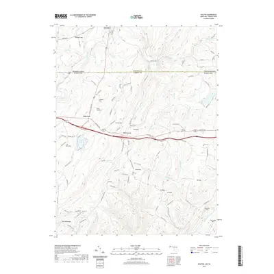
2019 Map of Avilton
USGS Topo · Published 2019About this map
Avilton and New Germany sit within a high-elevation landscape defined by the parallel ridges of the Allegheny Mountains. This terrain, marked by notable peaks such as Big Savage Mtn and Meadow Mtn, is crisscrossed by an intricate drainage system including the Casselman River and Savage River. The central corridor is dominated by the National Pike, which passes through Piney Grove near the crest of Red Ridge. This historic transit route dictates the settlement pattern, as small family burial grounds like Merrbach Cem and Mount Zion Cem appear alongside older farmsteads. To the south, the presence of New Germany Lake and Meadow Run Lake indicates a landscape shifting toward recreational use, while numerous named hollows and runs like Poplar Lick Run and Blue Lick Run reveal the complex topography that historically challenged early Appalachian travelers and settlers.
Find a feature on this map
98 named features on this map. Tap any name to fly to it.
Don’t see what you’re looking for? This feature index may not catch every label — zoom into the map to look around manually.
Map Details
Editions of this 2019 Avilton Map
This is the sole edition of this map. No revisions or reprints were ever made.
Other maps of this area

1898 · Frostburg
USGS Topo · 1:62,500

1899 · Grantsville
USGS Topo · 1:62,500

1901 · Frostburg
USGS Topo · 1:62,500

1904 · Grantsville
USGS Topo · 1:62,500

1908 · Frostburg
USGS Topo · 1:62,500

1921 · Meyersdale
USGS Topo · 1:62,500

1923 · Berlin
USGS Topo · 1:48,000

1929 · Berlin
USGS Topo · 1:62,500

1939 · Meyersdale
USGS Topo · 1:62,500

1944 · Berlin
USGS Topo · 1:62,500