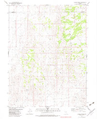
1982 Map of Ayarbe Spring
USGS Topo · Published 1982About this map
Antelope Valley defines the western expanse of this high-desert landscape in the early 1980s, where the boundary between Elko Co and White Pine Co crosses an arid basin. The map reveals the critical importance of water management in this livestock-grazing region, centered on Ayarbe Spring and its associated tank. These isolated water sources, along with Domingo Well to the north, are the primary markers of human utility in an otherwise open range. To the east, the terrain transitions into the heavily eroded Badlands, a complex network of ridges and drainages that contrast with the broader valley floor. A thin network of Jeep Trails provides the only passage through this remote Great Basin topography, illustrating the sparse settlement and rugged isolation characteristic of northeastern Nevada during this era.
Find a feature on this map
7 named features on this map. Tap any name to fly to it.
Don’t see what you’re looking for? This feature index may not catch every label — zoom into the map to look around manually.
Map Details
Editions of this 1982 Ayarbe Spring Map
This is the sole edition of this map. No revisions or reprints were ever made.
Other maps of this area

1955 · Elko
USGS Topo · 1:250,000

1956 · Ely
USGS Topo · 1:250,000

1958 · Elko
USGS Topo · 1:250,000

1959 · Ely
USGS Topo · 1:250,000

1962 · Elko
USGS Topo · 1:250,000

1963 · Ely
USGS Topo · 1:250,000

1965 · Elko
USGS Topo · 1:250,000

1979 · Sunset Reservoir
USGS Topo · 1:24,000
1981 · Spring Creek Flat NW
USGS Topo · 1:24,000
1981 · Georgetta Ranch
USGS Topo · 1:24,000