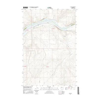
2017 Map of Ayer
USGS Topo · Published 2017About this map
Snake River dominates this portion of the border between Franklin and Walla Walla Counties, creating a deep corridor through the high plateau country of eastern Washington. Along its banks, small named points of interest such as Ayer, Rifton, and Chew mark the historical path of transportation and settlement within the river canyon. The creation of Lake Herbert G W transformed the river's flow, submerging former shorelines and creating the modern riparian environment seen here. Away from the water, the terrain rises sharply toward features like Fields Gulch, accessed by local routes such as Ayer Rd and Lyons Ferry Rd. This map captures the landscape of the mid-2010s, where rural access roads and large-scale water management projects define the local geography.
Find a feature on this map
16 named features on this map. Tap any name to fly to it.
Don’t see what you’re looking for? This feature index may not catch every label — zoom into the map to look around manually.
Map Details
Editions of this 2017 Ayer Map
This is the sole edition of this map. No revisions or reprints were ever made.
Other maps of this area

1919 · Walla Walla
USGS Topo · 1:125,000

1921 · Walla Walla
USGS Topo · 1:125,000

1948 · Starbuck
USGS Topo · 1:62,500

1948 · Ayer
USGS Topo · 1:62,500

1950 · Starbuck
USGS Topo · 1:62,500

1950 · Haas
USGS Topo · 1:62,500

1953 · Walla Walla
USGS Topo · 1:250,000

1958 · Walla Walla
USGS Topo · 1:250,000

1967 · Waitsburg NW
USGS Topo · 1:24,000
1967 · Clyde
USGS Topo · 1:24,000