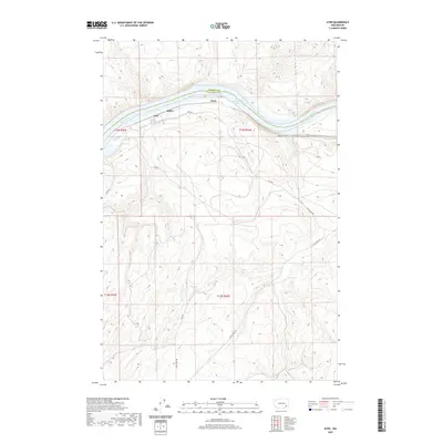
2020 Map of Ayer
USGS Topo · Published 2020About this map
The Snake River carves a deep valley through the high plateau of the Inland Empire, serving as the primary geographic corridor and boundary between Franklin and Walla Walla counties. The small settlement of Ayer and the nearby locality of Rifton occupy the southern banks, where the terrain transitions from the steep walls of Fields Gulch to the broader river terraces. This 2020 survey illustrates a landscape defined by the impounded waters of Lake Herbert G West, reflecting the modern regulated state of the river system. Transportation through this sparsely populated region is limited to a few arterial routes like Ayer Rd and Lyons Ferry Rd, which navigate the dramatic elevation changes between the riverbanks and the surrounding agricultural uplands. Smaller features such as Chew and Joe Barker Rd provide localized points of reference within the expansive canyon topography.
Find a feature on this map
15 named features on this map. Tap any name to fly to it.
Don’t see what you’re looking for? This feature index may not catch every label — zoom into the map to look around manually.
Map Details
Editions of this 2020 Ayer Map
This is the sole edition of this map. No revisions or reprints were ever made.
Other maps of this area

1919 · Walla Walla
USGS Topo · 1:125,000

1921 · Walla Walla
USGS Topo · 1:125,000

1948 · Starbuck
USGS Topo · 1:62,500

1948 · Ayer
USGS Topo · 1:62,500

1950 · Starbuck
USGS Topo · 1:62,500

1950 · Haas
USGS Topo · 1:62,500

1953 · Walla Walla
USGS Topo · 1:250,000

1958 · Walla Walla
USGS Topo · 1:250,000

1967 · Waitsburg NW
USGS Topo · 1:24,000
1967 · Clyde
USGS Topo · 1:24,000