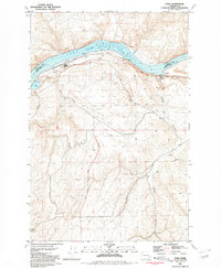
1981 Map of Ayer
USGS Topo · Published 1981About this map
The Snake River dominates this 1981 landscape at the boundary of Franklin and Walla Walla Counties. The river's character here is defined by Lake Herbert G West, a reservoir formed behind the Lower Monumental Dam. This reach of the river functions as a critical transportation corridor, where the Union Pacific railroad tracks follow the southern bank through the settlement of Ayer.
Find a feature on this map
23 named features on this map. Tap any name to fly to it.
Don’t see what you’re looking for? This feature index may not catch every label — zoom into the map to look around manually.
Map Details
Editions of this 1981 Ayer Map
This is the sole edition of this map. No revisions or reprints were ever made.
Other maps of this area

1919 · Walla Walla
USGS Topo · 1:125,000

1921 · Walla Walla
USGS Topo · 1:125,000

1948 · Starbuck
USGS Topo · 1:62,500

1948 · Ayer
USGS Topo · 1:62,500

1950 · Starbuck
USGS Topo · 1:62,500

1950 · Haas
USGS Topo · 1:62,500

1953 · Walla Walla
USGS Topo · 1:250,000

1958 · Walla Walla
USGS Topo · 1:250,000

1967 · Waitsburg NW
USGS Topo · 1:24,000
1967 · Clyde
USGS Topo · 1:24,000