
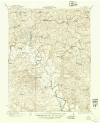
1933 Map of Aylett
USGS Topo · Published 1933About this map
The Mattaponi River serves as the central artery for this rural Virginia landscape, winding through the borderlands of King and Queen, Caroline, Essex, and King William counties. The settlement pattern is defined by river crossings and small milling hubs, where infrastructure like Mundys Bridge, Dunkirk Bridge, and Pointers Landing facilitated local commerce. Industry of the early twentieth century is clearly visible through the numerous mills operating along the creeks, including Broaddus Mill, Byrds Mill, and Watkins Mill. Social life in this agrarian region is anchored by a dense network of country schools and houses of worship, such as Newtown School, Ruffin School, and St Stephens Church. The map also captures several distinct crossroads communities like Beulahville, Indian Neck, and the village of Aylett, providing a detailed look at the rural road network and property orientation prior to mid-century modernization.
Find a feature on this map
81 named features on this map. Tap any name to fly to it.
Don’t see what you’re looking for? This feature index may not catch every label — zoom into the map to look around manually.
Map Details
Editions of this 1933 Aylett Map
2 editions found
Other maps of this area

1889 · Fredericksburg
USGS Topo · 1:125,000

1892 · Fredericksburg
USGS Topo · 1:125,000

1892 · Montross
USGS Topo · 1:62,500

1894 · Fredericksburg
USGS Topo · 1:125,000

1894 · Richmond
USGS Topo · 1:62,500

1895 · Richmond
USGS Topo · 1:62,500

1895 · Nomini
USGS Topo · 1:125,000

1895 · Montross
USGS Topo · 1:62,500

1898 · Nomini
USGS Topo · 1:125,000

1918 · Doswell
USGS Topo · 1:62,500