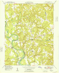
1949 Map of Aylett
USGS Topo · Published 1949About this map
The Mattaponi River carves a winding path through the borderlands of King William and King and Queen counties, defining the riverine economy and settlement patterns of this Virginia landscape in the late 1940s. Centered on the village of Aylett, the map reveals a community deeply tied to the water, where numerous historical river access points like Old Hall Landing, Jones Landing, and Painters Landing dot the banks. The presence of Aylett Mill and Aylett Pond indicates the continued importance of local milling operations powered by the river's tributaries.
Find a feature on this map
34 named features on this map. Tap any name to fly to it.
Don’t see what you’re looking for? This feature index may not catch every label — zoom into the map to look around manually.
Map Details
Editions of this 1949 Aylett Map
2 editions found
Other maps of this area

1918 · Tappahannock
USGS Topo · 1:62,500

1918 · Aylett
USGS Topo · 1:62,500

1919 · New Kent
USGS Topo · 1:62,500

1919 · Tappahannock
USGS Topo · 1:62,500

1920 · King William
USGS Topo · 1:62,500

1933 · Aylett
USGS Topo · 1:62,500

1943 · Richmond
USGS Topo · 1:250,000

1944 · Mount Landing
USGS Topo · 1:31,680
1944 · Howertons
USGS Topo · 1:24,000
1945 · Howertons
USGS Topo · 1:31,680