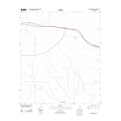
2012 Map of Bachelor Hill
USGS Topo · Published 2012About this map
Bachelor Hill anchors this high-elevation landscape in Crockett County, a region where water management is central to the local geography. The presence of Four Corner Windmill and Escondido Windmill reflects the critical infrastructure required for ranching and settlement in this part of Texas. These water-drawing landmarks, often tied to family lineages or specific grazing boundaries, serve as primary navigational points in an otherwise open terrain. The transportation network is defined by long-haul routes like Live Oak Rd and Hoover Divide Rd, which cross the territory to connect remote properties. This 2012 survey illustrates the modern configuration of access roads including Frontage Rd, showing how contemporary transit corridors have integrated with traditional ranching paths.
Find a feature on this map
6 named features on this map. Tap any name to fly to it.
Don’t see what you’re looking for? This feature index may not catch every label — zoom into the map to look around manually.
Map Details
Editions of this 2012 Bachelor Hill Map
This is the sole edition of this map. No revisions or reprints were ever made.
Other maps of this area

1929 · Sheffield
USGS Topo · 1:125,000

1954 · Sonora
USGS Topo · 1:250,000

1958 · Sonora
USGS Topo · 1:250,000

1967 · Owens Creek SE
USGS Topo · 1:24,000

1967 · Burnt Canyon
USGS Topo · 1:24,000

1967 · Pikes Peak
USGS Topo · 1:24,000
1967 · Schneeman Draw SW
USGS Topo · 1:24,000

1967 · Fort Lancaster
USGS Topo · 1:24,000

1967 · Bachelor Hill
USGS Topo · 1:24,000

1967 · Dead Man Canyon
USGS Topo · 1:24,000