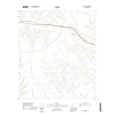
2019 Map of Bachelor Hill
USGS Topo · Published 2019About this map
Bachelor Hill rises above the arid landscape of Crockett County, serving as a prominent topographic landmark in this stretch of West Texas. The region is defined by significant drainage systems, most notably the wide paths of Escondido Draw and Mailbox Draw, which carve through the high plateau. Human activity is represented by the transit corridors of Interstate 10 and local ranch access routes like Live Oak Rd and Hoover Divide Rd. This survey, produced by the U.S. Geological Survey, provides a clear view of the complex contour patterns that characterize the transition from flat mesa tops to deep draws, reflecting the area's role in the regional cattle ranching economy and the modern transport infrastructure of the Southwestern United States.
Find a feature on this map
5 named features on this map. Tap any name to fly to it.
Don’t see what you’re looking for? This feature index may not catch every label — zoom into the map to look around manually.
Map Details
Editions of this 2019 Bachelor Hill Map
This is the sole edition of this map. No revisions or reprints were ever made.
Other maps of this area

1929 · Sheffield
USGS Topo · 1:125,000

1954 · Sonora
USGS Topo · 1:250,000

1958 · Sonora
USGS Topo · 1:250,000

1967 · Owens Creek SE
USGS Topo · 1:24,000

1967 · Burnt Canyon
USGS Topo · 1:24,000

1967 · Pikes Peak
USGS Topo · 1:24,000
1967 · Schneeman Draw SW
USGS Topo · 1:24,000

1967 · Fort Lancaster
USGS Topo · 1:24,000

1967 · Bachelor Hill
USGS Topo · 1:24,000

1967 · Dead Man Canyon
USGS Topo · 1:24,000