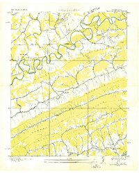
1935 Map of Back Valley
USGS Topo · Published 1935About this map
The Powell River snakes across the northern landscape of this 1935 survey, a deeply incised waterway defining the borderlands of Tennessee and Virginia. The rural social fabric of the era is remarkably dense with country institutions, from the Wolfenbarger Ch near the river to the Thomas Chapel tucked along Mulberry Creek. Numerous small schools like Mt Davis Sch and Sunnyside Sch suggest a landscape of self-contained valley communities connected by trails and early roads such as State Hy No 66.
Find a feature on this map
57 named features on this map. Tap any name to fly to it.
Don’t see what you’re looking for? This feature index may not catch every label — zoom into the map to look around manually.
Map Details
Editions of this 1935 Back Valley Map
This is the sole edition of this map. No revisions or reprints were ever made.
Other maps of this area

1883 · Morristown
USGS Topo · 1:125,000

1887 · Jonesville
USGS Topo · 1:125,000

1891 · Jonesville
USGS Topo · 1:125,000

1893 · Morristown
USGS Topo · 1:125,000

1895 · Morristown
USGS Topo · 1:125,000

1932 · Hagan
USGS Topo · 1:62,500
1935 · Ewing
USGS Topo · 1:24,000

1935 · Rogersville
USGS Topo · 1:48,000

1935 · Tate Springs
USGS Topo · 1:48,000

1935 · Lee Valley
USGS Topo · 1:24,000