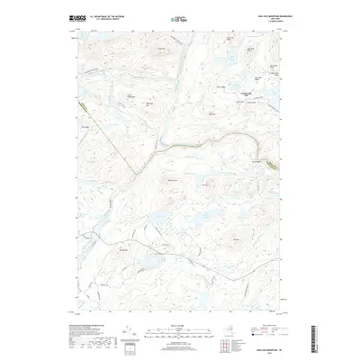
2019 Map of Bad Luck Mountain
USGS Topo · Published 2019About this map
Adirondack Park Preserve lands dominate this central Adirondack landscape, where the confluence of the Indian River and Hudson River creates a network of dramatic river bends and high ridges. The map documents the isolated Northwoods Club and Saints Rest at the end of Northwoods Club Rd, providing a clear record of established wilderness enclaves. The terrain is defined by a dense concentration of named peaks and ridges, including Bad Luck Mtn, Little Pisgah Mtn, and the distinctive Blue Ledge overlooking the Hudson. The abundance of interior water bodies like Big Bad Luck Pond and Essex Chain Lakes illustrates a landscape where early travel and modern conservation rely on these complex drainage patterns. Dozens of backcountry routes such as Stony Step Rd and Gooley Club Rd weave through the mountains, connecting high meadows like McGinn Meadows with the river valleys below.
Find a feature on this map
74 named features on this map. Tap any name to fly to it.
Don’t see what you’re looking for? This feature index may not catch every label — zoom into the map to look around manually.
Map Details
Editions of this 2019 Bad Luck Mountain Map
This is the sole edition of this map. No revisions or reprints were ever made.
Other maps of this area

1898 · Newcomb
USGS Topo · 1:62,500

1898 · Thirteenth Lake
USGS Topo · 1:62,500

1899 · Indian Lake
USGS Topo · 1:62,500

1901 · Newcomb
USGS Topo · 1:62,500

1902 · Indian Lake
USGS Topo · 1:62,500

1903 · Blue Mountain
USGS Topo · 1:62,500

1950 · Utica
USGS Topo · 1:250,000

1954 · Newcomb
USGS Topo · 1:62,500

1954 · Thirteenth Lake
USGS Topo · 1:62,500

1954 · Blue Mountain
USGS Topo · 1:62,500