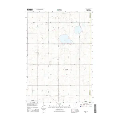
2015 Map of Badger
USGS Topo · Published 2015About this map
Badger sits at the northern edge of this Kingsbury County landscape, part of the elevated Coteau des Prairies plateau. The region is defined by a grid of agricultural roads, including 450th Ave and 200th St, which connect small communities like Hetland and the outskirts of Arlington. For local historians and genealogists, the map provides precise locations for several rural burial grounds, such as Badger Cem, Lake Thisted Cem, Nielsen Cem, and Hetland Cem. Water features are central to the terrain, notably Lake Badger and the smaller Lake Thisted near the eastern boundary. The presence of the Andersen Farms Airport south of Badger highlights the importance of private aviation in managing these large agricultural tracts. The layout reflects a deeply established township system, with section lines and county boundaries, including the border with Brookings County, clearly delineated.
Find a feature on this map
31 named features on this map. Tap any name to fly to it.
Don’t see what you’re looking for? This feature index may not catch every label — zoom into the map to look around manually.
Map Details
Editions of this 2015 Badger Map
This is the sole edition of this map. No revisions or reprints were ever made.
Other maps of this area

1953 · Watertown
USGS Topo · 1:250,000

1958 · Watertown
USGS Topo · 1:250,000

1968 · Lake Sinai
USGS Topo · 1:24,000

1968 · Lake Preston East
USGS Topo · 1:24,000

1968 · Lake Preston NE
USGS Topo · 1:24,000

1968 · Arlington
USGS Topo · 1:24,000

1968 · Arlington NE
USGS Topo · 1:24,000

1968 · Badger
USGS Topo · 1:24,000

1969 · Lake Norden
USGS Topo · 1:24,000

1969 · Lake Poinsett
USGS Topo · 1:24,000