
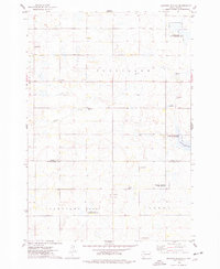
1968 Map of Badger
USGS Topo · Published 1970About this map
Glacial lakes and a dual-rail transport network define this portion of eastern South Dakota during the late 1960s. The Great Northern railroad cuts diagonally across the landscape, serving the community of Badger, while the Chicago And North Western line runs east-to-west through Hetland to the south. The terrain is marked by prominent water bodies like Lake Badger and Lake Thisted, with several small cemeteries, including Nielsen Cem and United Cem, scattered across the agricultural sections of Badger and Denver townships. This survey provides a precise record of rural life before further modern consolidation, showing a mix of infrastructure ranging from a Landing Field near Badger to the Arlington Municipal Airport on the eastern boundary. The presence of multiple Gravel Pits and Spring 3 suggests the localized importance of natural resources to the area's development.
Find a feature on this map
21 named features on this map. Tap any name to fly to it.
Don’t see what you’re looking for? This feature index may not catch every label — zoom into the map to look around manually.
Map Details
Editions of this 1968 Badger Map
This is the sole edition of this map. No revisions or reprints were ever made.
Other maps of this area

1953 · Watertown
USGS Topo · 1:250,000

1958 · Watertown
USGS Topo · 1:250,000

1968 · Lake Sinai
USGS Topo · 1:24,000

1968 · Lake Preston East
USGS Topo · 1:24,000

1968 · Lake Preston NE
USGS Topo · 1:24,000

1968 · Arlington
USGS Topo · 1:24,000

1968 · Arlington NE
USGS Topo · 1:24,000

1969 · Lake Norden
USGS Topo · 1:24,000

1969 · Lake Poinsett
USGS Topo · 1:24,000
1973 · Gertson Slough
USGS Topo · 1:24,000