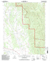
1994 Map of Badito Cone
USGS Topo · Published 1998About this map
Badito Cone rises as a prominent landmark in this transition between the high peaks of the San Isabel National Forest and the lower river valleys of Huerfano County. The drainage patterns of Custer Creek, Turkey Creek, and Maes Creek illustrate the rugged hydraulic landscape of southern Colorado in the late twentieth century. Family and local history is anchored by several burial grounds, including the Cisneros Cem and Maes Creek Cem, which sit near the winding course of the Huerfano River. Human activity is further evidenced by various Prospects and the Huerfano Ditch system, which reflects the region's historical reliance on irrigation and mineral exploration. The presence of the Wilderness Boundary and trails like the Bartlett Trail highlight the shift toward conservation and recreation on public lands during this era.
Find a feature on this map
27 named features on this map. Tap any name to fly to it.
Don’t see what you’re looking for? This feature index may not catch every label — zoom into the map to look around manually.
Map Details
Editions of this 1994 Badito Cone Map
This is the sole edition of this map. No revisions or reprints were ever made.
Other maps of this area

1889 · Huerfano Park
USGS Topo · 1:125,000

1891 · Walsenburg
USGS Topo · 1:125,000

1892 · Huerfano Park
USGS Topo · 1:125,000

1894 · Walsenburg
USGS Topo · 1:125,000

1897 · Walsenburg
USGS Topo · 1:125,000

1900 · Walsenburg
USGS Topo · 1:125,000

1954 · Trinidad
USGS Topo · 1:250,000

1955 · Trinidad
USGS Topo · 1:250,000

1958 · Trinidad
USGS Topo · 1:250,000

1959 · Trinidad
USGS Topo · 1:250,000