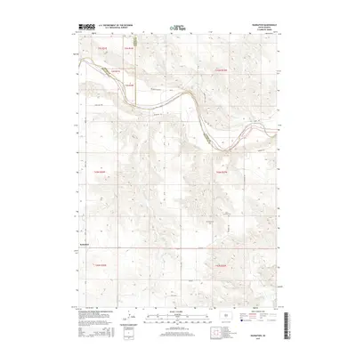
2015 Map of Badnation
USGS Topo · Published 2015About this map
The White River winds through this rural South Dakota landscape, defining the jagged border between Mellette, Jones, and Lyman counties. This 2015 survey reveals the sparse settlement patterns of the region, anchored by the community of Badnation in the southwestern corner. The terrain is deeply etched by a network of drainage systems, including Williams Cr, Louis Cr, and Oak Cr, which feed into the primary river valley. Human presence is marked by a handful of established ranch roads like Perry Ranch Rd and River-Side Dr. Cultural and genealogical history is concentrated near Pumpkin Rd, where both Saint Catherine Cem and Rosebud Cem are located. The map illustrates how local transportation and land use are dictated by the dramatic contours of the river breaks and the high plains surrounding them.
Find a feature on this map
28 named features on this map. Tap any name to fly to it.
Don’t see what you’re looking for? This feature index may not catch every label — zoom into the map to look around manually.
Map Details
Editions of this 2015 Badnation Map
This is the sole edition of this map. No revisions or reprints were ever made.
Other maps of this area

1951 · Badnation
USGS Topo · 1:24,000

1951 · Badnation NW
USGS Topo · 1:24,000

1951 · Presho 4 NW
USGS Topo · 1:24,000

1955 · Martin
USGS Topo · 1:250,000

1958 · Martin
USGS Topo · 1:250,000

1970 · Vivian SW
USGS Topo · 1:24,000

1972 · Vivian SE
USGS Topo · 1:24,000

1978 · Presho SW
USGS Topo · 1:24,000

1982 · Two Nation Creek
USGS Topo · 1:25,000

1982 · Wood North
USGS Topo · 1:24,000