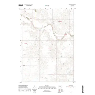
2017 Map of Badnation
USGS Topo · Published 2017About this map
The White River carves a winding path across this landscape in Mellette and Jones counties, dictating the road and settlement patterns of this section of South Dakota. The community of Badnation sits in the southwestern portion of the map, connected to the wider region by State Hwy 53. The terrain is defined by the drainage systems of several significant tributaries, including Williams Cr, Louis Cr, and Oak Cr, which create a complex network of draws and ridges. Local history is anchored by the presence of Saint Catherine Cem and Rosebud Cem, which sit atop the high ground overlooking the river valley. The infrastructure is primarily agricultural and rural, with routes like River Rd and Perry Ranch Rd following the natural contours of the river bends and the surrounding uplands.
Find a feature on this map
22 named features on this map. Tap any name to fly to it.
Don’t see what you’re looking for? This feature index may not catch every label — zoom into the map to look around manually.
Map Details
Editions of this 2017 Badnation Map
This is the sole edition of this map. No revisions or reprints were ever made.
Other maps of this area

1951 · Badnation
USGS Topo · 1:24,000

1951 · Badnation NW
USGS Topo · 1:24,000

1951 · Presho 4 NW
USGS Topo · 1:24,000

1955 · Martin
USGS Topo · 1:250,000

1958 · Martin
USGS Topo · 1:250,000

1970 · Vivian SW
USGS Topo · 1:24,000

1972 · Vivian SE
USGS Topo · 1:24,000

1978 · Presho SW
USGS Topo · 1:24,000

1982 · Two Nation Creek
USGS Topo · 1:25,000

1982 · Wood North
USGS Topo · 1:24,000