
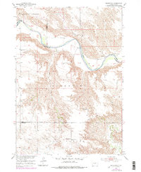
1951 Map of Badnation
USGS Topo · Published 1953About this map
The White River carves a deep, winding path through the rugged break-lands of Mellette and Lyman counties, defining the boundary and the difficult topography of the Riverside and Badnation regions. This 1951 survey documents a rural landscape where social life centered on small, dispersed educational and religious landmarks. For genealogists and local historians, the map preserves the locations of several mission and community churches, including St Catharine Ch, St George Ch, and Gilbert Ch. The educational network of the mid-century is represented by Riverside Sch, Pleasant View Sch, and Springview Sch. Of particular historical interest is the noted Bad Nation Indian Sch (Abandoned), which sits near the northern river bluffs, marking an earlier chapter of the region's indigenous history and institutional presence.
Find a feature on this map
19 named features on this map. Tap any name to fly to it.
Don’t see what you’re looking for? This feature index may not catch every label — zoom into the map to look around manually.
Map Details
Editions of this 1951 Badnation Map
2 editions found
Other maps of this area

1951 · Badnation NW
USGS Topo · 1:24,000

1951 · Presho 4 NW
USGS Topo · 1:24,000

1955 · Martin
USGS Topo · 1:250,000

1958 · Martin
USGS Topo · 1:250,000

1970 · Vivian SW
USGS Topo · 1:24,000

1972 · Vivian SE
USGS Topo · 1:24,000

1978 · Presho SW
USGS Topo · 1:24,000

1982 · Two Nation Creek
USGS Topo · 1:25,000

1982 · Wood North
USGS Topo · 1:24,000

1982 · Badnation SE
USGS Topo · 1:25,000