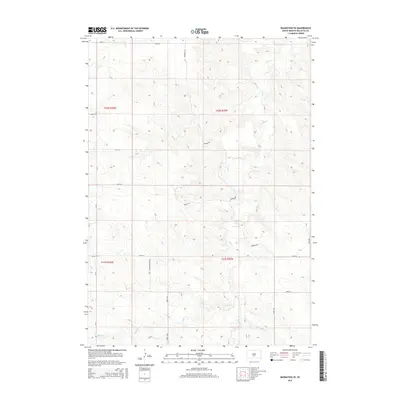
2015 Map of Badnation SE
USGS Topo · Published 2015About this map
Butte Cr and its tributaries carve a network of drainage patterns across this section of Mellette County, reflecting the erosive landscape of the northern plains. This 2015 survey illustrates a sparsely populated rural landscape where section lines and local roads such as Bad Whirlwind Rd and Rosebud Dr dictate the human footprint. The map serves as a record of modern tribal land management and ranching infrastructure, showing the relationship between water sources like Oak Cr and McChesneys Cr and the gridded road network including 290th Ave and 261st St. While few structures are named, the naming of watercourses and the precise surveying of township and range lines across Louis Cr provide a foundation for tracing land ownership and topographical changes in the Rosebud region.
Find a feature on this map
19 named features on this map. Tap any name to fly to it.
Don’t see what you’re looking for? This feature index may not catch every label — zoom into the map to look around manually.
Map Details
Editions of this 2015 Badnation SE Map
This is the sole edition of this map. No revisions or reprints were ever made.
Other maps of this area

1951 · Badnation
USGS Topo · 1:24,000

1951 · Badnation NW
USGS Topo · 1:24,000

1951 · Presho 4 NW
USGS Topo · 1:24,000

1955 · Martin
USGS Topo · 1:250,000

1958 · Martin
USGS Topo · 1:250,000

1982 · Two Nation Creek
USGS Topo · 1:25,000

1982 · Wood North
USGS Topo · 1:24,000

1982 · Badnation SE
USGS Topo · 1:25,000
1982 · Carter
USGS Topo · 1:25,000

1982 · Mosher
USGS Topo · 1:25,000