
1957 Map of Bailey Island
USGS Topo · Published 1992About this map
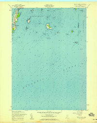
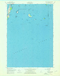
The settlement at Bailey Island serves as the focal point for this coastal survey of the Casco Bay region. Located within the township of Harpswell, the map details a complex maritime landscape where the granite-fringed coastline of Orrs Island and smaller outcroppings meet the Atlantic Ocean. Key navigational markers and hazardous shoals are meticulously noted, including the Jamison Ledge Beacon and numerous ledges such as Saddleback Ledge and Charity Ledge. The map captures the island's mid-century character, with structures concentrated around Mackerel Cove and connected by the slender crossing at Wills Gut. Beyond the inhabited areas, the archipelago extends into the bay with Flag Island, Ragged Island, and Pond Island, reflecting the traditional fishing and seafaring heritage of Cumberland County's outer islands.
Find a feature on this map
40 named features on this map. Tap any name to fly to it.
Don’t see what you’re looking for? This feature index may not catch every label — zoom into the map to look around manually.
Map Details
Editions of this 1957 Bailey Island Map
3 editions found
Other maps of this area

1892 · Freeport
USGS Topo · 1:62,500

1893 · Small Point
USGS Topo · 1:62,500

1893 · Casco Bay
USGS Topo · 1:62,500

1894 · Bath
USGS Topo · 1:62,500

1914 · Casco Bay
USGS Topo · 1:48,000

1916 · Casco Bay
USGS Topo · 1:62,500

1916 · Portland And Vicinity
USGS Topo · 1:62,500

1918 · Portland And Vicinity
USGS Topo · 1:62,500

1919 · Small Point
USGS Topo · 1:62,500

1920 · Bath
USGS Topo · 1:62,500