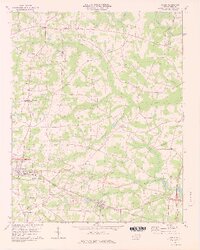
1978 Map of Bailey
USGS Topo · Published 1978About this map
The agricultural landscape of the Nash and Wilson County border area is defined by the winding courses of the Tar River and a network of blackwater drainages including Toisnot Swamp and Bloomeru Swamp. The towns of Bailey and Sims serve as the primary population centers, oriented along the Norfolk Southern railroad line that cuts through the southern portion of the quadrangle. This 1970s survey captures the region's rural character, where small settlements like Mount Pleasant and Stanhope are anchored by crossroads and country churches such as Floods Chapel and Whiteoak Hill Ch.
Find a feature on this map
38 named features on this map. Tap any name to fly to it.
Don’t see what you’re looking for? This feature index may not catch every label — zoom into the map to look around manually.
Map Details
Editions of this 1978 Bailey Map
3 editions found
Other maps of this area

1902 · Kenly
USGS Topo · 1:62,500

1902 · Rocky Mount
USGS Topo · 1:62,500

1902 · Spring Hope
USGS Topo · 1:62,500

1903 · Kenly
USGS Topo · 1:62,500

1904 · Rocky Mount
USGS Topo · 1:62,500

1904 · Springhope
USGS Topo · 1:62,500

1904 · Wilson
USGS Topo · 1:62,500

1953 · Rocky Mount
USGS Topo · 1:250,000

1953 · Raleigh
USGS Topo · 1:250,000

1954 · Rocky Mount
USGS Topo · 1:250,000