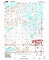
1997 Map of Baileys Lake
USGS Topo · Published 2001About this map
Great Salt Lake dominates the northwest corner of this landscape, where the shifting wetlands of the Farmington Bay Waterfowl Management Area meet the industrial and agricultural edges of the Salt Lake Valley. This 1997 data shows a territory defined by water management and recreational use, featuring numerous private hunting grounds like the Lake Front Duck Club and Rudy Duck Club scattered across the mud flats and knolls. The transition from the marshy Cow Bay to the developing urban fringe of Salt Lake City is visible through a complex network of man-made waterways, including the Surplus Canal and Goggin Drain. In the south, the industrial footprint of the valley is evident near Riter, where large-scale Salt Evaporators and extensive tailings piles indicate the heavy resource extraction near the Salt Lake City Corporate Boundary.
Find a feature on this map
33 named features on this map. Tap any name to fly to it.
Don’t see what you’re looking for? This feature index may not catch every label — zoom into the map to look around manually.
Map Details
Editions of this 1997 Baileys Lake Map
This is the sole edition of this map. No revisions or reprints were ever made.
Other maps of this area

1885 · Salt Lake
USGS Topo · 1:250,000

1885 · Tooele Valley
USGS Topo · 1:250,000

1925 · Ft. Douglas
USGS Topo · 1:125,000

1928 · Ft. Douglas
USGS Topo · 1:125,000

1951 · Saltair
USGS Topo · 1:24,000

1951 · Salt Lake City South
USGS Topo · 1:24,000

1951 · Salt Lake City North
USGS Topo · 1:24,000

1952 · Saltair NE
USGS Topo · 1:24,000

1952 · Farmington
USGS Topo · 1:24,000

1952 · Magna
USGS Topo · 1:24,000