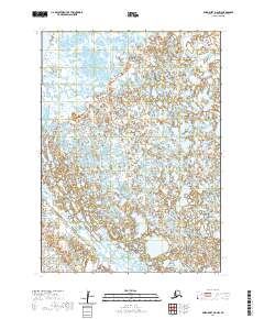
2020 Map of Baird Inlet B-8 NW
USGS Topo · Published 2020About this map
Nightmute serves as a primary settlement node in this 2020 landscape, situated along the winding course of the Toksook River. The terrain is defined by a dense, intricate network of wetlands and small lakes characteristic of the Bering Sea coastal plains. This particular section of the Yukon-Kuskokwim Delta illustrates the transition from the mainland water systems to the elevated landform of Nelson Island in the southeast. The mapping reveals a sparse but vital human footprint, where transport and subsistence are dictated by the seasonally shifting waterways of the Toksook River drainage basin, an area of significant cultural importance for the Central Alaskan Yup'ik people.
Find a feature on this map
10 named features on this map. Tap any name to fly to it.
Don’t see what you’re looking for? This feature index may not catch every label — zoom into the map to look around manually.
Map Details
Editions of this 2020 Baird Inlet B-8 NW Map
This is the sole edition of this map. No revisions or reprints were ever made.
Other maps of this area

1951 · Nunivak Island
USGS Topo · 1:250,000

1951 · Baird Inlet
USGS Topo · 1:250,000

1954 · Nunivak Island
USGS Topo · 1:250,000

1954 · Baird Inlet
USGS Topo · 1:250,000

1954 · Baird Inlet C-8
USGS Topo · 1:63,360

1954 · Nunivak Island B-1
USGS Topo · 1:63,360

1954 · Baird Inlet B-8
USGS Topo · 1:63,360

1954 · Nunivak Island C-1
USGS Topo · 1:63,360

1958 · Nunivak Island
USGS Topo · 1:250,000

1964 · Nunivak Island
USGS Topo · 1:250,000