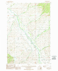
1989 Map of Baker
USGS Topo · Published 1989About this map
Baker sits at the heart of this high-desert valley landscape in Lemhi County, situated where the Lemhi River serves as the primary drainage for numerous mountain tributaries. The map reveals a complex hydraulic network defined by irrigation and local ranching interests, with the river valley flanked by the steep foothills of the Salmon National Forest. Named drainages like Bohannon Creek, Wimpey Creek, and Haynes Creek cut through the terrain, suggesting the importance of water rights and seasonal flows in this part of Idaho. Evidence of early resource extraction and land use is visible through several labeled features, including a Prospect and an Adit in the northern hills, while a modern Radio Tower and Sub Station indicate the mid-20th-century infrastructure developments that supported this rural community. The concentration of development along the valley floor contrasts sharply with the untamed eastern slopes leading toward West Fork Sandy Creek.
Find a feature on this map
25 named features on this map. Tap any name to fly to it.
Don’t see what you’re looking for? This feature index may not catch every label — zoom into the map to look around manually.
Map Details
Editions of this 1989 Baker Map
This is the sole edition of this map. No revisions or reprints were ever made.
Other maps of this area

1950 · Salmon
USGS Topo · 1:62,500

1951 · Salmon
USGS Topo · 1:62,500

1955 · Dubois
USGS Topo · 1:250,000

1955 · Dillon
USGS Topo · 1:250,000

1956 · Goldstone Mtn
USGS Topo · 1:62,500

1956 · Lemhi
USGS Topo · 1:62,500

1957 · Dillon
USGS Topo · 1:250,000

1958 · Dubois
USGS Topo · 1:250,000

1958 · Dillon
USGS Topo · 1:250,000

1962 · Dillon
USGS Topo · 1:250,000