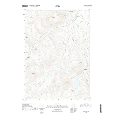
2019 Map of Bakers Mills
USGS Topo · Published 2019About this map
Bakers Mills and the high peaks of the Adirondacks define this mountain landscape within the town of Johnsburg. The terrain is marked by a complex system of drainage and small ponds, including the Fish Ponds and Lizard Pond south of Kettle Mtn. The East Branch Sacandaga River flows through the western portion of the area near the small settlement of Oregon, where the elevations of Square Falls Mtn and Barker Mtn create a steep valley. Transportation is restricted to winding local roads like Bartman School Rd and Co Rd 72, which skirt the bases of summits like Eleventh Mtn and Mt Blue. The presence of Garnet Lake in the southeast corner provides a focal point for the lower elevations, surrounded by family-named landmarks such as Gillingham Knoll and Buck Hill.
Find a feature on this map
47 named features on this map. Tap any name to fly to it.
Don’t see what you’re looking for? This feature index may not catch every label — zoom into the map to look around manually.
Map Details
Editions of this 2019 Bakers Mills Map
This is the sole edition of this map. No revisions or reprints were ever made.
Other maps of this area

1895 · North Creek
USGS Topo · 1:62,500

1897 · North Creek
USGS Topo · 1:62,500

1898 · Thirteenth Lake
USGS Topo · 1:62,500

1903 · Luzerne
USGS Topo · 1:62,500

1910 · Stony Creek
USGS Topo · 1:62,500

1950 · Glens Falls
USGS Topo · 1:250,000

1950 · Utica
USGS Topo · 1:250,000

1954 · Thirteenth Lake
USGS Topo · 1:62,500

1954 · Harrisburg
USGS Topo · 1:62,500
1955 · Lake Luzerne
USGS Topo · 1:62,500