
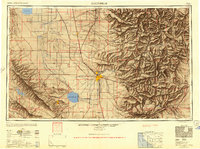
1948 Map of Bakersfield
USGS Topo · Published 1948About this map
The Bakersfield hub and the fertile expanse of the southern San Joaquin Valley dominate this post-war landscape, showing a region defined by extensive irrigation and rail connectivity. The presence of Tulare Lake and Buena Vista Lake illustrates a hydraulic environment before later mid-century water projects further altered these natural basins. Transportation networks are meticulously detailed, from the primary Southern Pacific and Atchison Topeka and Santa Fe lines to the localized Sunset Railway serving the oil and agricultural districts near Taft and Maricopa. To the east, the dramatic rise of the Sierra Nevada includes the Sequoia National Forest and the Tule River Indian Reservation. Agricultural colonies and small rail stops like Allensworth and Delano populate the valley floor, while Gardner Field stands as a reminder of military aviation in the region during the 1940s.
Find a feature on this map
101 named features on this map. Tap any name to fly to it.
Don’t see what you’re looking for? This feature index may not catch every label — zoom into the map to look around manually.
Map Details
Editions of this 1948 Bakersfield Map
2 editions found
Other maps of this area

1902 · Santa Ynez
USGS Topo · 1:125,000

1903 · Mt. Pinos
USGS Topo · 1:125,000

1903 · Tejon
USGS Topo · 1:125,000

1904 · Kaweah
USGS Topo · 1:125,000

1905 · Santa Ynez
USGS Topo · 1:125,000

1905 · Lompoc
USGS Topo · 1:125,000

1905 · Olancha
USGS Topo · 1:125,000

1905 · Fairview
USGS Topo · 1:24,000

1906 · Bakersfield
USGS Topo · 1:62,500

1906 · Kernville
USGS Topo · 1:125,000