1948 Map of Bakersfield
USGS Topo · Published 1948About this map
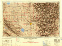
Bakersfield stands as the central hub of this late-1940s landscape, where the agricultural expanse of the Central Valley meets the rising Tehachapi Mountains. The map reveals a highly engineered water system essential for the region's growth, featuring the Homeland Canal, Kern Island Canal, and the remnants of Tulare Lake and Buena Vista Lake. This era highlights the intense industrialization of the valley floor, specifically the massive Standard Oil Company Tank Farm and the emerging aviation infrastructure at Bakersfield-Kern County Airport and Minter. To the east, the terrain shifts abruptly into the Sierra Nevada foothills and the Piute Mountains, where the Southern Pacific and Atchison Topeka and Santa Fe railroads navigate the steep grades of Tehachapi Pass. Smaller settlements like Allensworth and Buttonwillow dot the irrigation-dependent plains, while isolated mining operations like the Tungsten Chief Mine appear in the eastern heights.
Find a feature on this map
168 named features on this map. Tap any name to fly to it.
Don’t see what you’re looking for? This feature index may not catch every label — zoom into the map to look around manually.
Map Details
Editions of this 1948 Bakersfield Map
2 editions found

Other maps of this area

1902 · Santa Ynez
USGS Topo · 1:125,000

1903 · Mt. Pinos
USGS Topo · 1:125,000

1903 · Tejon
USGS Topo · 1:125,000

1904 · Kaweah
USGS Topo · 1:125,000

1905 · Santa Ynez
USGS Topo · 1:125,000

1905 · Lompoc
USGS Topo · 1:125,000

1905 · Olancha
USGS Topo · 1:125,000

1905 · Fairview
USGS Topo · 1:24,000

1906 · Bakersfield
USGS Topo · 1:62,500

1906 · Kernville
USGS Topo · 1:125,000