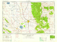
1960 Map of Bakersfield
USGS Topo · Published 1960About this map
Bakersfield serves as the central hub of this mid-century landscape, situated where the Kern River meets a complex network of agricultural irrigation and rail infrastructure. To the north and west, the vast basin floor is defined by the ephemeral footprints of Tulare Lake and Buena Vista Lake, surrounded by drainage features like the Kern Island Canal and Homeland Canal. This era shows a heavily managed valley floor with established agricultural towns like Delano, Wasco, and Shafter flanking the Southern Pacific Railroad.
Find a feature on this map
133 named features on this map. Tap any name to fly to it.
Don’t see what you’re looking for? This feature index may not catch every label — zoom into the map to look around manually.
Map Details
Editions of this 1960 Bakersfield Map
2 editions found

Other maps of this area

1902 · Santa Ynez
USGS Topo · 1:125,000

1903 · Mt. Pinos
USGS Topo · 1:125,000

1903 · Tejon
USGS Topo · 1:125,000

1904 · Kaweah
USGS Topo · 1:125,000

1905 · Santa Ynez
USGS Topo · 1:125,000

1905 · Lompoc
USGS Topo · 1:125,000

1905 · Olancha
USGS Topo · 1:125,000

1905 · Fairview
USGS Topo · 1:24,000

1906 · Bakersfield
USGS Topo · 1:62,500

1906 · Kernville
USGS Topo · 1:125,000