
1960 Map of Bakersfield
USGS Topo · Published 1960About this map
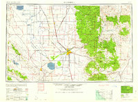
Bakersfield serves as the central hub of this 1960 survey, a landscape defined by an intensive network of irrigation canals and the rising industrial presence of the energy sector. To the north, the sprawling footprints of Tulare Lake and Buena Vista Lake contrast with the engineered precision of the Friant-Kern Canal and Homeland Canal, illustrating the monumental efforts to manage water in the Southern San Joaquin Valley. The eastern reaches of the sheet climb abruptly into the Sierra Nevada and Tehachapi Mountains, where the Sequoia National Forest and Tule River Indian Reservation dominate the high country.
Find a feature on this map
110 named features on this map. Tap any name to fly to it.
Don’t see what you’re looking for? This feature index may not catch every label — zoom into the map to look around manually.
Map Details
Editions of this 1960 Bakersfield Map
2 editions found
Other maps of this area

1902 · Santa Ynez
USGS Topo · 1:125,000

1903 · Mt. Pinos
USGS Topo · 1:125,000

1903 · Tejon
USGS Topo · 1:125,000

1904 · Kaweah
USGS Topo · 1:125,000

1905 · Santa Ynez
USGS Topo · 1:125,000

1905 · Lompoc
USGS Topo · 1:125,000

1905 · Olancha
USGS Topo · 1:125,000

1905 · Fairview
USGS Topo · 1:24,000

1906 · Bakersfield
USGS Topo · 1:62,500

1906 · Kernville
USGS Topo · 1:125,000