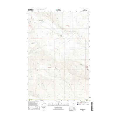
2017 Map of Bald Butte
USGS Topo · Published 2017About this map
The Little Snowy Mountains dominate this central Montana landscape along the border of Fergus County and Musselshell County. This 2017 terrain study highlights the complex drainage system of the area, defined by the convergence of several major creeks including N Fork Flatwillow Cr, S Fork Flatwillow Cr, and Whoop-Up Cr. The namesake Bald Butte stands as a prominent landmark in the southwestern portion of the quadrangle, while Daley Gap and Durfee Gap provide natural passages through the elevated ridges to the east.
Find a feature on this map
25 named features on this map. Tap any name to fly to it.
Don’t see what you’re looking for? This feature index may not catch every label — zoom into the map to look around manually.
Map Details
Editions of this 2017 Bald Butte Map
This is the sole edition of this map. No revisions or reprints were ever made.
Other maps of this area

1889 · Big Snowy Mountain
USGS Topo · 1:250,000

1893 · Big Snowy Mountain
USGS Topo · 1:250,000

1954 · Roundup
USGS Topo · 1:250,000

1958 · Roundup
USGS Topo · 1:250,000

1970 · Forestgrove
USGS Topo · 1:24,000

1970 · South Bench
USGS Topo · 1:24,000

1986 · Tyler
USGS Topo · 1:24,000

1986 · Devils Hole Lake
USGS Topo · 1:24,000

1986 · Pender Coulee
USGS Topo · 1:24,000
1986 · Sahara Hill
USGS Topo · 1:24,000