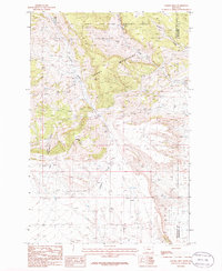
1986 Map of Sahara Hill
USGS Topo · Published 1986About this map
The Little Snowy Mountains dominate the northern terrain of this 1980s Montana landscape, where the high-altitude topography of the Lewis and Clark National Forest transitions into the drainage basins of the southern plains. Central to the sheet is the prominent rise of Sahara Hill, a distinctive landmark situated between the headwaters of Stonehouse Creek and the winding path of Cameron Creek. The area is defined by sharp elevation changes and deep incisions like Stonehouse Canyon, illustrating a transition zone between forested peaks and the open range. In addition to the complex network of spring-fed waters such as the North Fork Minerva Creek and Ray Creek, the map details the political boundary where Golden Valley and Musselshell counties meet in the northeast corner, providing a clear record of land use and administrative borders in this part of Big Sky Country.
Find a feature on this map
9 named features on this map. Tap any name to fly to it.
Don’t see what you’re looking for? This feature index may not catch every label — zoom into the map to look around manually.
Map Details
Editions of this 1986 Sahara Hill Map
This is the sole edition of this map. No revisions or reprints were ever made.
Other maps of this area

1889 · Big Snowy Mountain
USGS Topo · 1:250,000

1893 · Big Snowy Mountain
USGS Topo · 1:250,000

1954 · Roundup
USGS Topo · 1:250,000

1958 · Roundup
USGS Topo · 1:250,000

1970 · South Bench
USGS Topo · 1:24,000
1970 · Alaska Bench
USGS Topo · 1:24,000

1986 · Devils Hole Lake
USGS Topo · 1:24,000

1986 · Patterson Canyon
USGS Topo · 1:24,000

1986 · Emory School
USGS Topo · 1:24,000
1986 · Sahara Hill SE
USGS Topo · 1:24,000