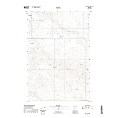
2020 Map of Bald Butte
USGS Topo · Published 2020About this map
Bald Butte rises as a prominent landmark in this section of Fergus County, where the northern foothills of the Little Snowy Mountains meet a network of high-plains watercourses. The landscape is defined by the drainages of N Fork Flatwillow Cr and S Fork Flatwillow Cr, which create a series of benches and draws utilized for ranching. Evidence of this land use is found at the N Bar Ranch Airport, located along Upper Flatwillow Rd.
Find a feature on this map
26 named features on this map. Tap any name to fly to it.
Don’t see what you’re looking for? This feature index may not catch every label — zoom into the map to look around manually.
Map Details
Editions of this 2020 Bald Butte Map
This is the sole edition of this map. No revisions or reprints were ever made.
Other maps of this area

1889 · Big Snowy Mountain
USGS Topo · 1:250,000

1893 · Big Snowy Mountain
USGS Topo · 1:250,000

1954 · Roundup
USGS Topo · 1:250,000

1958 · Roundup
USGS Topo · 1:250,000

1970 · Forestgrove
USGS Topo · 1:24,000

1970 · South Bench
USGS Topo · 1:24,000

1986 · Tyler
USGS Topo · 1:24,000

1986 · Devils Hole Lake
USGS Topo · 1:24,000

1986 · Pender Coulee
USGS Topo · 1:24,000
1986 · Sahara Hill
USGS Topo · 1:24,000