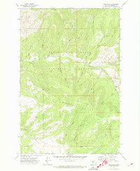
1971 Map of Bald Hills
USGS Topo · Published 1974About this map
Lewis and Clark National Forest spans this mountain landscape in Meagher County, defined by the sharp transition between the Rimrock Ridge and the deep drainage of Tenderfoot Creek. The 1971 survey captures a pocket of Montana wilderness where human activity is limited to remote outposts like the Zehntner Ranch and scattered industrial traces, including a Mine and a Prospect located near the northern slopes. The topography is intricately dissected by seasonal coulees and gulches, such as Cow Coulee and Deadman Gulch, which feed into larger water systems like Blacktail Creek. Navigation across these high elevations, ranging from Old Baldy to the Bald Hills, relies on a network of a Pack Trail and a Jeep Trail, illustrating the rugged, non-motorized access typical of this national forest interior during the early 1970s.
Find a feature on this map
30 named features on this map. Tap any name to fly to it.
Don’t see what you’re looking for? This feature index may not catch every label — zoom into the map to look around manually.
Map Details
Editions of this 1971 Bald Hills Map
This is the sole edition of this map. No revisions or reprints were ever made.
Other maps of this area

1886 · Great Falls
USGS Topo · 1:250,000

1886 · Fort Logan
USGS Topo · 1:250,000

1948 · White Sulphur Springs
USGS Topo · 1:250,000

1954 · Great Falls
USGS Topo · 1:250,000

1957 · Great Falls
USGS Topo · 1:250,000

1958 · White Sulphur Springs
USGS Topo · 1:250,000

1961 · White Sulphur Springs
USGS Topo · 1:250,000

1965 · White Sulphur Springs
USGS Topo · 1:250,000

1966 · Lingshire NE
USGS Topo · 1:24,000
1966 · Ellis Canyon
USGS Topo · 1:24,000