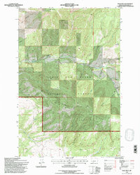
1995 Map of Bald Hills
USGS Topo · Published 1997About this map
Lewis and Clark National Forest dominates this mountain landscape, defined by a complex drainage system that funnels into Tenderfoot Creek. The topography is marked by significant elevations like Old Baldy and the Bald Hills, while the prominent Rimrock Ridge cuts across the southern portion of the quadrangle. Resource extraction and ranching history are evident through the numerous Prospects and the Zehntner Ranch located along the South Fork. The network of drainages, including Indiana Gulch, Lion Gulch, and Strawberry Gulch, illustrates the steep, broken terrain that dictated local land use and boundary lines such as the Kings Hill Ranger District National Forest Boundary.
Find a feature on this map
24 named features on this map. Tap any name to fly to it.
Don’t see what you’re looking for? This feature index may not catch every label — zoom into the map to look around manually.
Map Details
Editions of this 1995 Bald Hills Map
This is the sole edition of this map. No revisions or reprints were ever made.
Other maps of this area

1886 · Great Falls
USGS Topo · 1:250,000

1886 · Fort Logan
USGS Topo · 1:250,000

1948 · White Sulphur Springs
USGS Topo · 1:250,000

1954 · Great Falls
USGS Topo · 1:250,000

1957 · Great Falls
USGS Topo · 1:250,000

1958 · White Sulphur Springs
USGS Topo · 1:250,000

1961 · White Sulphur Springs
USGS Topo · 1:250,000

1965 · White Sulphur Springs
USGS Topo · 1:250,000

1966 · Lingshire NE
USGS Topo · 1:24,000
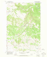
1966 · Ellis Canyon
USGS Topo · 1:24,000