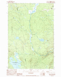
1989 Map of Bald Mtn Pond
USGS Topo · Published 1989About this map
Shirley Mills sits at the northeastern edge of this Maine landscape, where the West Branch Piscataquis River and numerous brooks define the drainage patterns of the late 1980s. The terrain transitions from the low wetlands of Shirley Bog and Oakes Bog to the prominent heights of Bald Mountain and Breakneck Ridge. This map captures a remote section of the Maine woods, showing the Appalachian National Scenic Trail as it winds through the southern portion of the quadrangle, crossing Bald Mountain Stream and passing near the expansive Bald Mountain Pond. The survey highlights the historic township divisions of East Moxie and Blanchard Plt, reflecting a region dominated by logging, waterpower, and seasonal camps. Key landmarks like Hatch Falls and the small Cem near the village provide specific points of interest for those researching the local geography of Shirley.
Find a feature on this map
31 named features on this map. Tap any name to fly to it.
Don’t see what you’re looking for? This feature index may not catch every label — zoom into the map to look around manually.
Map Details
Editions of this 1989 Bald Mtn Pond Map
This is the sole edition of this map. No revisions or reprints were ever made.
Other maps of this area

1903 · Bingham
USGS Topo · 1:62,500

1905 · Bingham
USGS Topo · 1:62,500

1905 · The Forks
USGS Topo · 1:62,500

1907 · The Forks
USGS Topo · 1:62,500

1948 · Kingsbury
USGS Topo · 1:62,500

1950 · Kingsbury
USGS Topo · 1:62,500

1951 · Greenville
USGS Topo · 1:62,500

1954 · Millinocket
USGS Topo · 1:250,000

1956 · The Forks
USGS Topo · 1:62,500

1956 · Bingham
USGS Topo · 1:62,500
Featured Places
- Shirley, ME
- Blanchard Township, ME
- East Moxie Township, ME
- Bald Mountain Township, ME
- Somerset County, ME