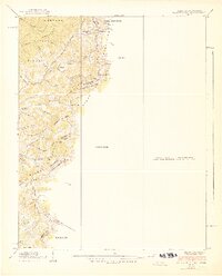
1939 Map of Baldwin Gap
USGS Topo · Published 1939About this map
Stone Mountain and the high ridges along the Tennessee and North Carolina border anchor this 1938 field study. The landscape is defined by its series of narrow gaps and family-named hollows, where small settlements like Hemlock and rural institutions established themselves in the rugged drainage of the South Fork. High-altitude life is reflected in the placement of the Laurel Springs Sch and the Curd Sch, alongside numerous community landmarks such as Bethel Ch and Hammon Chapel. This era precedes significant modernization in the region, capturing the intricate network of local branches like Furnace Cr and Payne Branch that dictated the placement of early homes and cemeteries, including the Payne Cem and Wallace Cem. The proximity of the Cherokee National Forest highlights the intersection of protected mountain lands and private valley farming at the cusp of the 1940s.
Find a feature on this map
58 named features on this map. Tap any name to fly to it.
Don’t see what you’re looking for? This feature index may not catch every label — zoom into the map to look around manually.
Map Details
Editions of this 1939 Baldwin Gap Map
2 editions found
Other maps of this area

1891 · Abingdon
USGS Topo · 1:125,000

1893 · Cranberry
USGS Topo · 1:125,000

1894 · Abingdon
USGS Topo · 1:125,000

1895 · Cranberry
USGS Topo · 1:125,000

1899 · Cranberry
USGS Topo · 1:125,000

1902 · Cranberry
USGS Topo · 1:125,000

1909 · Abingdon
USGS Topo · 1:96,000

1911 · Abingdon
USGS Topo · 1:125,000

1935 · Grayson
USGS Topo · 1:24,000

1935 · Park
USGS Topo · 1:24,000