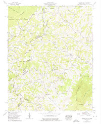
1959 Map of Baldwin Gap
USGS Topo · Published 1975About this map
The Tennessee-North Carolina state line follows the high crest of Stone Mountain in this 1959 survey, where the rugged topography of the Blue Ridge defines local life. Small, family-centered settlements like Ashland and Creston are situated along the lower elevations where the North Fork New River and its tributaries carve narrow valleys through the terrain. The map is exceptionally dense with genealogical details, documenting dozens of family burial grounds such as McEwen Cem, Winebarger Cem, and Graybeal Cem, alongside country congregations like Rock Creek Methodist Church. Education and community hubs are found at the Forge Sch and Hammon Chapel. The survey illustrates a landscape of high ridges like Pond Mountain and numerous named hollows, including Payne Hollow and Johnson Hollow, that organized the rural settlement patterns of the era.
Find a feature on this map
108 named features on this map. Tap any name to fly to it.
Don’t see what you’re looking for? This feature index may not catch every label — zoom into the map to look around manually.
Map Details
Editions of this 1959 Baldwin Gap Map
4 editions found
Other maps of this area

1891 · Abingdon
USGS Topo · 1:125,000

1893 · Cranberry
USGS Topo · 1:125,000

1894 · Abingdon
USGS Topo · 1:125,000

1895 · Cranberry
USGS Topo · 1:125,000

1899 · Cranberry
USGS Topo · 1:125,000

1902 · Cranberry
USGS Topo · 1:125,000

1909 · Abingdon
USGS Topo · 1:96,000

1911 · Abingdon
USGS Topo · 1:125,000

1935 · Grayson
USGS Topo · 1:24,000

1935 · Park
USGS Topo · 1:24,000