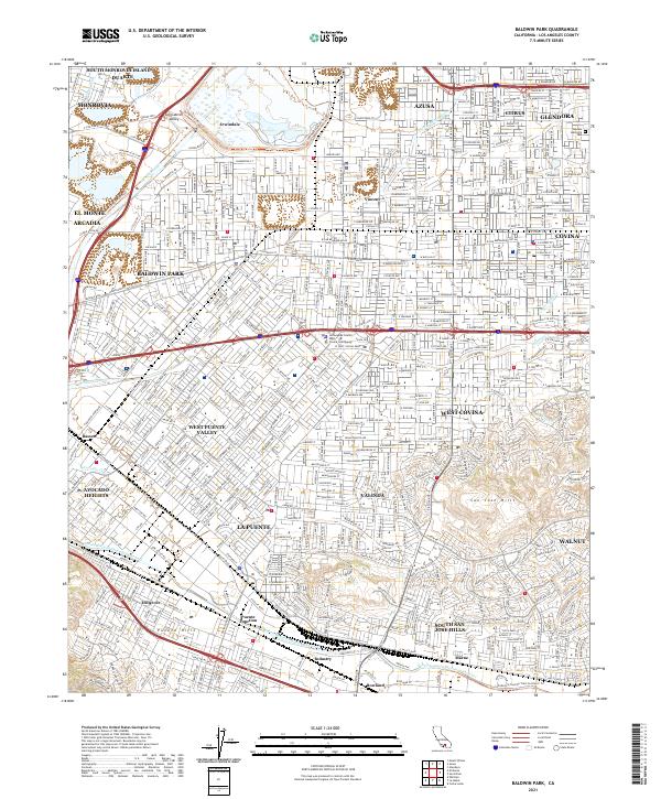
2021 Map of Baldwin Park
USGS Topo · Published 2021About this map
The San Gabriel Valley is a dense network of suburban development and critical water infrastructure as of 2021. The San Gabriel River defines the western edge, accompanied by the San Gabriel River Trl, while the San Jose Hills and Puente Hills provide topographic relief to the south and east. Significant civil engineering is evident in the San Jose Creek Diversion Channel and several washes like Little Dalton Wash, which manage the region's complex hydrology. The map details a contiguous urban corridor connecting Baldwin Park, Covina, and West Covina, where historical transit points like Puente Junction and Hillgrove persist amid modern residential expansion. Prominent landmarks such as Oakdale Memorial Park and the Los Angeles County West Covina Courthouse serve as major navigational and community anchors within this busy Los Angeles County landscape.
Find a feature on this map
78 named features on this map. Tap any name to fly to it.
Don’t see what you’re looking for? This feature index may not catch every label — zoom into the map to look around manually.
Map Details
Editions of this 2021 Baldwin Park Map
This is the sole edition of this map. No revisions or reprints were ever made.
Historical Maps of Azusa Through Time
3 maps found