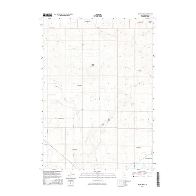
2017 Map of Baldy Knoll
USGS Topo · Published 2017About this map
Baldy Knoll and the surrounding high ground of Lemhi Ridge dominate the landscape of Bingham County in this recent survey. The southeastern portion of the map reveals a critical agricultural corridor where the Aberdeen Springfield Canal, Peoples Canal, and Highline Ditch converge to manage water resources in this arid Idaho terrain. Near these waterways, the small settlement of McDonaldville is situated along Macdonaldville Rd, representing the primary human cluster in an area otherwise characterized by geometric township grids and rural thoroughfares like Larsen Rd and Munson Loop. The northern reaches include Morgans Pasture and several prominent landforms, including Lemhi Pass, which provides a natural break in the ridgeline. This survey illustrates the continued reliance on extensive canal systems to support habitation and land use in the high desert.
Find a feature on this map
29 named features on this map. Tap any name to fly to it.
Don’t see what you’re looking for? This feature index may not catch every label — zoom into the map to look around manually.
Map Details
Editions of this 2017 Baldy Knoll Map
This is the sole edition of this map. No revisions or reprints were ever made.
Other maps of this area

1940 · Blackfoot
USGS Topo · 1:62,500

1943 · Blackfoot
USGS Topo · 1:62,500

1955 · Baldy Knoll
USGS Topo · 1:24,000

1955 · Rockford
USGS Topo · 1:24,000

1955 · Rose
USGS Topo · 1:24,000

1955 · Idaho Falls
USGS Topo · 1:250,000

1958 · Idaho Falls
USGS Topo · 1:250,000
1964 · Morgans Pasture NE
USGS Topo · 1:24,000
1971 · Blackfoot
USGS Topo · 1:24,000
1971 · Moreland
USGS Topo · 1:24,000