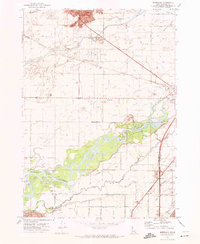
1971 Map of Moreland
USGS Topo · Published 1974About this map
Agricultural development and water management define this portion of the upper Snake River Plain in the early 1970s. The landscape is dominated by a complex network of irrigation infrastructure, including the Aberdeen Springfield Canal, Peoples Canal, and numerous family and community-named ditches like Duncan Ditch and Welch Ditch. These systems support the established settlements of Moreland, Groveland, and Riverside, which are concentrated north of the Snake River. The Blackfoot River meanders across the southern portion of the sheet, where it enters the Fort Hall Indian Reservation. Transportation is centered on the Union Pacific railroad lines, which converge at Aberdeen Junction near a prominent grain elevator, signaling the area's deep ties to the regional farming economy. For genealogists, the map is particularly useful for locating burial sites such as the Moreland Cemetery and the Thomas Riverside Cemetery.
Find a feature on this map
63 named features on this map. Tap any name to fly to it.
Don’t see what you’re looking for? This feature index may not catch every label — zoom into the map to look around manually.
Map Details
Editions of this 1971 Moreland Map
This is the sole edition of this map. No revisions or reprints were ever made.
Other maps of this area

1940 · Blackfoot
USGS Topo · 1:62,500

1943 · Blackfoot
USGS Topo · 1:62,500

1955 · Baldy Knoll
USGS Topo · 1:24,000

1955 · Rockford
USGS Topo · 1:24,000

1955 · Rose
USGS Topo · 1:24,000

1955 · Pingree
USGS Topo · 1:24,000

1955 · Idaho Falls
USGS Topo · 1:250,000

1958 · Idaho Falls
USGS Topo · 1:250,000
1971 · Fort Hall
USGS Topo · 1:24,000
1971 · Buckskin Basin
USGS Topo · 1:24,000