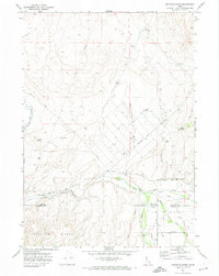
1971 Map of Buckskin Basin
USGS Topo · Published 1974About this map
The Fort Hall Main Canal and a dense network of irrigation channels like the Wenee Ditch and Farmer Ditch define the agricultural landscape of the Fort Hall Indian Reservation in the early 1970s. This survey illustrates the intricate water management system serving the valley floor beneath the Pocatello Range and Hyram Butte. The southern portion of the map is anchored by the Ross Fork Indian School and Putnam Lodge, centers of local community activity near the Bingham and Bannock county line.
Find a feature on this map
31 named features on this map. Tap any name to fly to it.
Don’t see what you’re looking for? This feature index may not catch every label — zoom into the map to look around manually.
Map Details
Editions of this 1971 Buckskin Basin Map
This is the sole edition of this map. No revisions or reprints were ever made.
Other maps of this area

1937 · Pocatello
USGS Topo · 1:48,000

1940 · Blackfoot
USGS Topo · 1:62,500

1943 · Blackfoot
USGS Topo · 1:62,500

1944 · Pocatello
USGS Topo · 1:62,500

1954 · Pocatello
USGS Topo · 1:250,000
1955 · Lincoln Creek
USGS Topo · 1:24,000

1955 · Yandell Springs
USGS Topo · 1:62,500

1955 · Idaho Falls
USGS Topo · 1:250,000

1958 · Idaho Falls
USGS Topo · 1:250,000

1958 · Pocatello
USGS Topo · 1:250,000