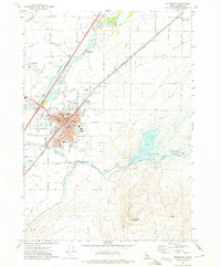
1971 Map of Blackfoot
USGS Topo · Published 1974About this map
Blackfoot serves as the focal point of this 1970s Idaho landscape, positioned at the confluence of the Snake River and the Blackfoot River. The town's layout is defined by the Union Pacific rail line and a dense network of civic structures, including the Post Office, Court House, and State Hospital South. Notable for local historians is the Eastern Idaho State Fairgrounds and the Grove City Cem north of the city center.
Find a feature on this map
55 named features on this map. Tap any name to fly to it.
Don’t see what you’re looking for? This feature index may not catch every label — zoom into the map to look around manually.
Map Details
Editions of this 1971 Blackfoot Map
This is the sole edition of this map. No revisions or reprints were ever made.
Other maps of this area

1940 · Blackfoot
USGS Topo · 1:62,500

1943 · Blackfoot
USGS Topo · 1:62,500

1955 · Baldy Knoll
USGS Topo · 1:24,000

1955 · Lincoln Creek
USGS Topo · 1:24,000

1955 · Rose
USGS Topo · 1:24,000

1955 · Firth
USGS Topo · 1:24,000

1955 · Yandell Springs
USGS Topo · 1:62,500

1955 · Idaho Falls
USGS Topo · 1:250,000

1958 · Idaho Falls
USGS Topo · 1:250,000
1971 · Fort Hall
USGS Topo · 1:24,000