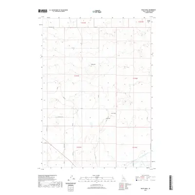
2020 Map of Baldy Knoll
USGS Topo · Published 2020About this map
Aberdeen Springfield Canal and the Peoples Canal define the southern landscape of this Idaho quadrangle, illustrating the vital irrigation infrastructure of Bingham County. The terrain is characterized by geological landmarks such as Baldy Knoll and the prominent Lemhi Ridge to the east. Transportation through this rural area follows a grid-like network of local roads including Larsen Rd and Sagebrush Rd, while the passage through higher ground is marked by Lemhi Pass. A distinct pattern of grazing and land use is evident in named areas like Morgans Pasture, situated near the northern boundary. The integration of irrigation ditches like the Highline Ditch with these named ranching features reflects the agricultural development of the region during this period.
Find a feature on this map
28 named features on this map. Tap any name to fly to it.
Don’t see what you’re looking for? This feature index may not catch every label — zoom into the map to look around manually.
Map Details
Editions of this 2020 Baldy Knoll Map
This is the sole edition of this map. No revisions or reprints were ever made.
Other maps of this area

1940 · Blackfoot
USGS Topo · 1:62,500

1943 · Blackfoot
USGS Topo · 1:62,500

1955 · Baldy Knoll
USGS Topo · 1:24,000

1955 · Rockford
USGS Topo · 1:24,000

1955 · Rose
USGS Topo · 1:24,000

1955 · Idaho Falls
USGS Topo · 1:250,000

1958 · Idaho Falls
USGS Topo · 1:250,000
1964 · Morgans Pasture NE
USGS Topo · 1:24,000
1971 · Blackfoot
USGS Topo · 1:24,000
1971 · Moreland
USGS Topo · 1:24,000