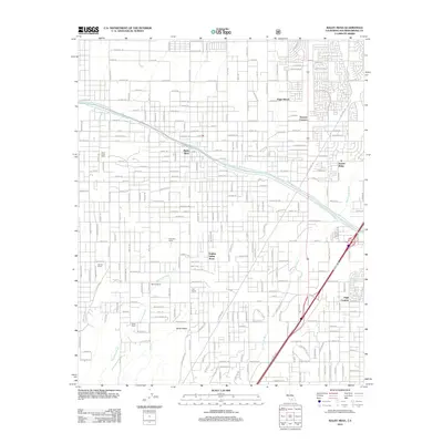
2012 Map of Baldy Mesa
USGS Topo · Published 2012About this map
The Governor Edmund G Brown California Aqueduct cuts a diagonal path through the high desert landscape, serving as a primary marker for the region's mid-century water infrastructure. This survey captures a transitional zone where residential subdivisions like Golden Valley Acres and Eagle Ranch began to intermingle with established agricultural holdings. The map records numerous family-named landmarks including the Patterson Ranch, Warner Ranch, and Fish Ranch, which indicate the area's legacy of ranching prior to extensive suburban development. Two major natural drainage systems, the Oro Grande Wash and Manzanita Wash, reveal the natural topography that early surveyors and developers had to navigate. The placement of Duncan Corners and High Country highlights the expansion of the community along the north-south transport corridor, providing a clear record of the area's growth patterns at the start of the 2010s.
Find a feature on this map
152 named features on this map. Tap any name to fly to it.
Don’t see what you’re looking for? This feature index may not catch every label — zoom into the map to look around manually.
Map Details
Editions of this 2012 Baldy Mesa Map
This is the sole edition of this map. No revisions or reprints were ever made.
Other maps of this area

1901 · Southern California Sheet No. 1
USGS Topo · 1:250,000

1902 · Hesperia
USGS Topo · 1:62,500

1903 · San Antonio
USGS Topo · 1:62,500

1904 · Southern California Sheet No. 1
USGS Topo · 1:250,000

1932 · Barstow
USGS Topo · 1:125,000

1934 · Barstow
USGS Topo · 1:125,000

1937 · Shadow Mountains
USGS Topo · 1:48,000
1942 · San Antonio
USGS Topo · 1:62,500

1942 · Hesperia
USGS Topo · 1:62,500

1942 · Shadow Mountains
USGS Topo · 1:62,500