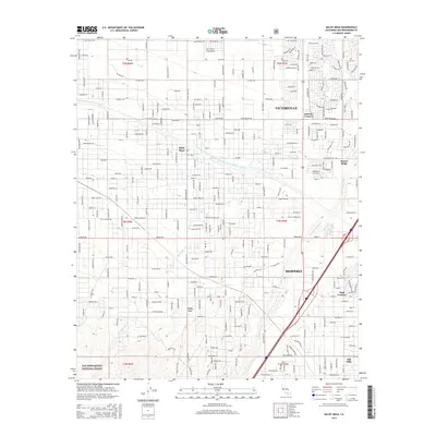
2015 Map of Baldy Mesa
USGS Topo · Published 2015About this map
Victorville and Hesperia anchor this 2015 study of a rapidly developing High Desert landscape. The residential expansion of the High Desert is visible through the dense grid of streets north of Bear Valley Rd and the developing neighborhoods of Oak Hills and High Country. Significant engineering and infrastructure projects dominate the central portion of the sheet, most notably the Governor Edmund G Brown East Branch California Aqueduct, which winds through the terrain alongside natural drainage features like Oro Grande Wash and Manzanita Wash. To the south, the edge of the San Bernardino National Forest provides a stark contrast to the subdivided lots of the nearby communities. For local historians, the map documents specific named residential pockets like Duncan Corners and Sunset Ridge, as well as the transition from the steep terrain of Baldy Mesa into the flatlands of the Victor Valley.
Find a feature on this map
191 named features on this map. Tap any name to fly to it.
Don’t see what you’re looking for? This feature index may not catch every label — zoom into the map to look around manually.
Map Details
Editions of this 2015 Baldy Mesa Map
This is the sole edition of this map. No revisions or reprints were ever made.
Other maps of this area

1901 · Southern California Sheet No. 1
USGS Topo · 1:250,000

1902 · Hesperia
USGS Topo · 1:62,500

1903 · San Antonio
USGS Topo · 1:62,500

1904 · Southern California Sheet No. 1
USGS Topo · 1:250,000

1932 · Barstow
USGS Topo · 1:125,000

1934 · Barstow
USGS Topo · 1:125,000

1937 · Shadow Mountains
USGS Topo · 1:48,000
1942 · San Antonio
USGS Topo · 1:62,500

1942 · Hesperia
USGS Topo · 1:62,500

1942 · Shadow Mountains
USGS Topo · 1:62,500