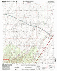
1996 Map of Baldy Mesa
USGS Topo · Published 1999About this map
Baldy Mesa dominates the landscape of this High Desert transition zone, where the northern slopes of the San Gabriel Mountains meet the Mojave. The California Aqueduct carves a prominent engineered line across the terrain, illustrating the massive mid-century infrastructure required to transport water through the arid interior. This 1996 revision, based on updated aerial photography, reveals a region defined by scattered residential development and enduring agrarian footprints. Local history is anchored by a series of named ranch sites, including Yucca Forest Ranch, Patterson Ranch, and Warner Ranch, which speak to the area's pastoral roots. Significant portions of the southern quadrangle are protected within the San Bernardino National Forest, where the topography becomes increasingly complex as it rises away from the desert floor. The network of drainage features like Oro Grande Wash and White Wash underscores the seasonal hydrology of the mesa.
Find a feature on this map
14 named features on this map. Tap any name to fly to it.
Don’t see what you’re looking for? This feature index may not catch every label — zoom into the map to look around manually.
Map Details
Editions of this 1996 Baldy Mesa Map
This is the sole edition of this map. No revisions or reprints were ever made.
Other maps of this area

1901 · Southern California Sheet No. 1
USGS Topo · 1:250,000

1902 · Hesperia
USGS Topo · 1:62,500

1903 · San Antonio
USGS Topo · 1:62,500

1904 · Southern California Sheet No. 1
USGS Topo · 1:250,000

1932 · Barstow
USGS Topo · 1:125,000

1934 · Barstow
USGS Topo · 1:125,000

1937 · Shadow Mountains
USGS Topo · 1:48,000
1942 · San Antonio
USGS Topo · 1:62,500

1942 · Hesperia
USGS Topo · 1:62,500

1942 · Shadow Mountains
USGS Topo · 1:62,500