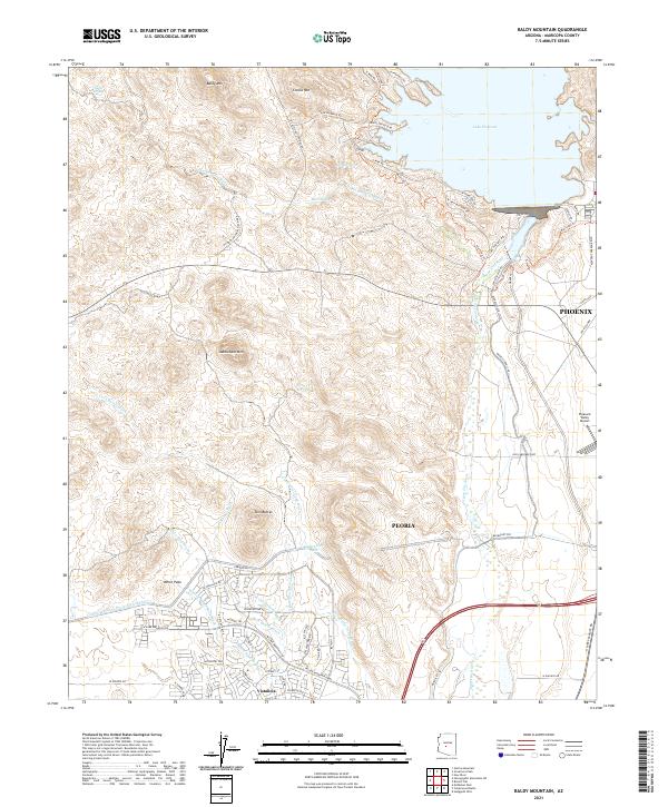
2021 Map of Baldy Mountain
USGS Topo · Published 2021About this map
Lake Pleasant dominates the northeastern corner of this Maricopa County landscape, where the Agua Fria River meets the recreation-focused terrain north of Phoenix. This modern survey illustrates the northward expansion of the valley's suburbs, most notably seen in the master-planned community of Vistancia. This development sits south of the prominent White Peak and is bounded to the north by the massive Central Arizona Project Aqueduct, a critical piece of water infrastructure cutting through the desert floor.
Find a feature on this map
70 named features on this map. Tap any name to fly to it.
Don’t see what you’re looking for? This feature index may not catch every label — zoom into the map to look around manually.
Map Details
Editions of this 2021 Baldy Mountain Map
This is the sole edition of this map. No revisions or reprints were ever made.
Other maps of this area

1954 · Phoenix
USGS Topo · 1:250,000

1957 · Phoenix
USGS Topo · 1:250,000

1957 · Calderwood Butte
USGS Topo · 1:24,000

1957 · McMicken Dam
USGS Topo · 1:24,000

1957 · Hedgpeth Hills
USGS Topo · 1:24,000

1958 · Phoenix
USGS Topo · 1:250,000

1960 · Phoenix
USGS Topo · 1:250,000
1964 · Garfias Mountain
USGS Topo · 1:24,000
1964 · New River
USGS Topo · 1:24,000
1964 · Governors Peak
USGS Topo · 1:24,000